Tag Archives: Port St Denis

Leg 13 – St Denis to St Martin de Ré – 8 August 2013

Port St Denis d’Oléron marina was a huge parking lot for Merry Fisher boats
click to enlarge
Port St Denis d’Oléron was crowded. The only visitors’ pontoon was tightly packed and Play d’eau was on the inside of a raft of four; the bulk of the marina seems to be a huge parking lot for Merry Fisher boats.

The Capitainerie staff was brilliant. Under their direction boats were shuffled to give us an outside position against an old beautiful (but actually brand new) 60’ twin masted sailing boat for the last night so we could leave early for St Martin on Île de Ré. Perfect.

The nav plan

The two pinch points (it always seems to be two, doesn’t it?) on this journey were the entry/exit times at both Port St Denis and St Martin de Ré, but given the passage time was just over two hours, it wouldn’t be a problem.

The Journey

St Martin de Ré – our mooring overlapped the yachts in front
click to enlarge
Casting off at 0551, we used the FLIR camera to pick our way through the unlit buoyed channel to the sea. Exciting!

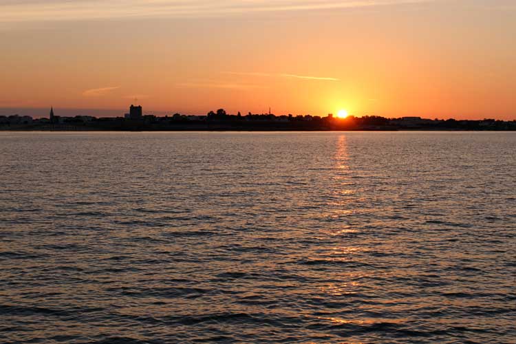
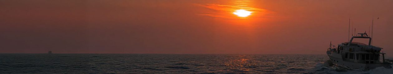
The journey itself was lovely with twilight changing to dawn as we neared Île de Ré. So beautiful.

The forecast was for W/NW winds F2 but reality was entirely different with an E’ly F3. It’s been interesting that forecast winds seem to bear nothing to reality in this area of the Vendée.

Arriving

Calling the St Martin Capitainerie on ch 9, we were told there was no space until the evening. In the hope this would change as more boats left in the half hour before the lock closed, we hooked onto one of the visitors’ buoys. Determined to keep Play d’eau in the forefront of the Capitainerie’s mind, I called again to announce we were moored to ‘bouée seize’. ‘D’accord,’ came the reply.

A few minutes later we heard, ‘Vedette Play d’eau, ici St Martin. Il y a une place maintenant. Venez vite puisque l’écluse se ferme en dix minutes’. (Please excuse my dreadful knowledge of French…)

We unhooked, venezed vite, très vite, and moored to the smallest pontoon space I’ve ever seen between two rafts of boats four deep, just as the lock gate closed behind us.

There was not a lot of space behind, either
click to enlarge
As we all know, mooring is not so much a skill but a spectator sport. Finally, as we eased Play d’eau against the pontoon with her bows overhanging six feet into the space in front between the bows of the two rafted yachts, we were give a round of applause!

Whilst taking a bow, a cheery Welsh voice drifted across the marina, ‘Hi Piers!’ It was Mike and Heidi of Yacht El Aranque, whom we’d met in La Rochelle. For Mike, read Dale Nelson.

Within moments we had a Princess 52 and four yachts rafted alongside.

Memories

Looking at how the boats were stacked reminded me of Kim Hollamby leading his MBM cruise in company fleets. You needed to use a feeler gauge to measure how close he’d packed them all in….

The tecky details

Departed Port St Denis d’Oléron – 0551
Hooked St Martin de Ré visitor’s buoy (No 16) – 0802
Unhooked the buoy – 0818
Moored St Martin de Ré – 0830

Total distance – 16.6nm
Longest leg – 12.9nm from Port St Denis WP to Grand Greffe ECM
Tech issues – nil

Piers and Lin
from the Nav Table of
Play d’eau
Fleming 55

You can get in touch with us any time by using our Contact Form.

Leg 12 – Rochefort to St Denis d’Oléron – 5 August 2013

Sunrise over the Embouchure de la Charante almost two hours after leaving Rochefort
click to enlarge
At 0500 the swing bridge swung, the lock gate unlocked and the green exit light greened. Casting off at 0507, we eased our way towards the exit in the glow of the marina’s spartan lighting.

The Harbour Master was there to bid us farewell. ‘Bonne navigation,’ he called. ‘A l’anée prochain,’ we responded.

Who turned the lights out?

Leaving the lock to enter the river it was as if someone suddenly turned all the lights out – literally. Nothing, but nothing could be seen apart from a few distant spots of light from a house or car, and with sunrise not expected until 0638 we had a good 45 minutes or so before anything might be seen with pre-dawn twilight giving us plenty of time in which to find a mud bank….

Instead, we navigated on instruments with the screen of our FLIR thermal imaging camera displaying the river ahead. The detail was stunning. It was as if it was daylight. The ripples on the water, terns swimming and taking off as we approached, branches of trees – how brilliant was that?

The SW corner of Île d’Aix where we anchored in glassy flat seas. Soon, the sky darkened, the wind changed and picked up, and the seas started to mis-behave
click to enlarge
Concentrating on that, the radar and depth sounder, we threaded our way deeper into the black as if blindfold. The FLIR was exceptional. With the chart plotter as back up, all was well – even our heart rates.

The nav plan

Two main pinch points on this journey to Port St Denis in Île d’Oléron.

Departure from Rochefort was limited to 0500 – 0530 and entry to Port St Denis was limited to between 1600 and 1800.

This gave us far too much time to cover the 25nm journey so we planned to break the journey part way by anchoring off the west side of Île d’Aix in the lee of any E’ly wind, have breakfast, sleep, catch up with some work, and leave for Port St Denis at 1445.

The Journey

Having exited the Embouchure de la Charante we dropped anchor 0732 in a perfect spot; flat, silky calm, and completely shielded from the wind.

The Capitainerie at Port St Denis, Île d’Olérone
click to enlarge
With the anchor’s snubbing line installed, the anchor ball proud in Play d’eau’s bows, Lin produced a cooked breakfast of ‘eggy bread’ (scrummy) and we sat back to enjoy the day. Well, that was the intention.

Where did that come from?

Soon after 1100, the sky darkened, the wind changed to a NW’ly at 15 gusting 23kts and started to build a sea with a tall, short and rather nasty chop. We began to roll around. This hadn’t been forecast.

Given our earliest arrival time at Port St Denis, we couldn’t leave until 1445. Moving anchorage wasn’t an option either; all the allowed anchorages were either exposed to this wind and/or the endless wakes caused by the multiple fast ferries that ply between the islands.

We braved it out, eventually weighing anchor at 1445 and heading for Port St Denis. At times, spray flew over the top of Play d’eau as she pitched, sometimes rather excitedly, whilst the stabilisers coped brilliantly with any roll.

The sand is really soft and a lovely deep orange golden colour
click to enlarge

As ever, Play d’eau coped well, nothing was broken and I gave her a good long bath when we arrived.

Arriving

Port St Denis was crowded, as if the world of ‘those who normally anchor out’ had taken shelter. We managed to squeeze into a space giving barely a metre at either end, and within no time at all we had two large yachts rafted up against us.

At least we weren’t rolling anymore and Lin, for one, was happy.

The tecky details

Departed Rochefort – 0507
Arrived Île d’Aix – 0732
Departed Île d’Aix – 1445
Arrived Port St Denis – 1620

Total distance – 24.9nm
Longest leg – 12.9nm from Rochefort to the Embouchure de la Charante
Tech issues – nil

Piers and Lin
From the Nav table of
Play d’eau
Fleming 55

You can get in touch with us any time by using our Contact Form.